The use of GPS in aviation
Since its launch in 1994, the Global Positioning System (GPS) has impacted our lives in many ways. Maintained by the United States government, it is freely available to anyone with a GPS receiver – including for military, civil and commercial use.
Many of us use GPS every day through our smartphones, watches or in-car navigation systems. But how is GPS used to facilitate aviation? PrivateFly investigates.
Ten facts about GPS
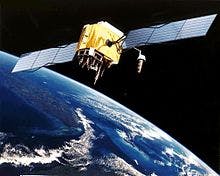
- GPS is enabled by a network of satellites – between 24 and 32 are currently operational at any one time.
- These satellites are encircling our planet in geo-stationary orbit – an orbit that keeps its distance to earth equal at any time.
- A user device only requires an unobstructed line of sight to 4 of these satellites to be able to position any place on earth correctly – regardless of weather conditions.
- Development started in 1973, designed to overcome the limitations of previous navigation systems. GPS then became fully operational in 1994, initially with 24 satellites.
- The oldest GPS satellite still in operation was launched on November 26, 1990, and became operational on December 10, 1990.
- In Russia, the Russian Global Navigation Satellite System (GLONASS) has been available since 2007 – previously it was for military use only.
- Other countries are also developing their own systems, including Europe’s own navigation system, Galileo – due to become operational in 2014.
- The uses of GPS are multitude including: Locating shipwrecks; Studying animal behaviour; recovering lost pets; and geocaching (treasure hunting).
- GPS data has helped scientists to make more precise measurements of Mount Everest, with recent studies confirming that it is actually getting taller through tectonic movement.
- There are now thousands of location-based smartphone apps which use GPS. These allow you to use your location to navigate, receive personalised information, access local services or to share your location with others.
GPS in the PrivateFly iPhone App
PrivateFly’s new iPhone app includes an intelligent Jet Me Home function, powered by GPS.
This gives instant pricing for a private jet charter to your closest home airport, from wherever you are in the world.
GPS in Air Traffic Control
Aircraft have been tracked by radar since World War II. Despite major advances radar is still relatively expensive and requires large infrastructure. Radar is also vulnerable to changing conditions and physical obstacles. But with the GPS, a simple but precise solution is already available and installed in every aircraft.
Both private jet aircraft and commercial airliners now use GPS to navigate within centimetres of their intended track and flight path. This is then graphically presented to the pilots on the flight deck.
A GPS transmitting device sends information such as speed, bearing and altitude in regular intervals over to air traffic control. It is not only a much more cost effective but also more precise solution to the problem. Unlike a transponder reflecting back data calls sent from the ground, GPS on aircraft can send the information itself.
In August 2007, the Federal Aviation Authority (FAA) awarded a $1 billion USD contract to start construction of a new air traffic control system based on GPS. This will allow air traffic controllers to see aircraft movements in real-time, allowing more aircraft movements in an even safer operation.
GPS Approaches to Airfields
In the USA, private jets are able to access small airfields in bad weather by using GPS approaches. This increases the efficiency of every flight by saving flight time and preventing aircraft from diverting in bad weather.
In Europe GPS approach aids are still limited to a very limited number of airports and have not yet been widely adapted, despite pilots much preferring them over traditional and inaccurate ground based approach procedures.
However there are several projects currently under development to change this. Zurich Airport (ZRH/LSZH) is currently building a new GPS approach for its runway 14. Pilots will then follow a series of waypoints which will be automatically picked up by the cockpit instruments. The first test has already been completed successfully on a Swiss Airbus A320 during the summer of 2010.
Related content
Three special ‘Leap Day’ trips by private jet

7 business aviation predictions for 2020